


 FE Courses
 PE Courses
 SE Courses
 Continuing Education
 Pmp Courses
 Corportate Training
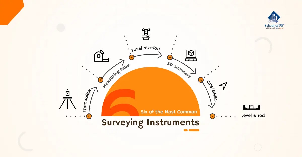
Table of Contents
1. Theodolite: A surveying instrument with a rotating telescope for measuring horizontal and vertical angles to make precise measurements of areas and triangulate the position of objects in a specific area2.
2. Measuring tape: A length of tape or thin flexible metal, marked at intervals for measuring size or distance. Surveyors commonly use tape measures (known as measuring wheels) in lengths of over 100 meters3.
3. Total station: A theodolite that uses electronics to calculate angles and distances and contains an on-board computer to collect data and perform triangulation calculations. This tool is used to record features in topographic surveying or to set out features (roads, houses, or boundaries)4.
4. 3D scanners: A surveying instrument that can accurately measure and collect data from objects, surfaces, buildings, and landscapes. This tool collects information in the form of point cloud data, which consists of millions of 3D coordinates. These coordinates can be used to create 3D computer-aided design (CAD) models, which can then help analyze topographic features and structures. The high accuracy of 3D scanners helps reduce project costs5.
Ready to test your knowledge? Explore our practice exams now!
5. GPS/GNSS: The use of Global Positioning System signals and/or Global Navigation Satellite System signals via a receiver and antenna to determine the form, boundary, position, objects, or points in space relative to other forms, boundaries, or points. This technology has dramatically increased the speed and productivity of surveyors using OnDemand centimeter-level accuracy provided by Real-Time Kinematic (RTK) positioning6.
6. Level and rod: A graduated wooden or aluminum rod, used with a levelling instrument to determine the difference in height between points or heights of points above a vertical datum7. This tool is used to establish and verify elevations.
Surveying is critical to the construction of new roads and structures necessary to fulfill our population's needs. Surveying engineers use a combination of different tools to help them gather the data necessary to map, chart, and measure. Are you interested in surveying engineering? School of PE is offering both Fundamentals of Surveying (FS) and Principles and Practice of Surveying (PS) exam review courses! Learn more today: https://www.schoolofpe.com/surveying.
References:
1 "How to Use the Roman Groma." De Legione Romana. Accessed June 30, 2021. https://legioneromana.altervista.org/content/how-use-roman-groma?language=en.
2 "All About Theodolites." Johnson Level, 2015. https://www.johnsonlevel.com/News/TheodolitesAllAboutTheodo.
3 Johnson, Ian. "How To Read a Tape Measure." The Tape Store, February 14, 2014. https://www.thetapestore.co.uk/knowledgebase/How/How_to_Read_a_Tape_Measure.html
4 "Total Stations." EngineerSupply. Accessed June 30, 2021. https://www.engineersupply.com/total-stations.aspx.
5 "What Is Laser Scanning and How Can It Be Used?" TopoDOT Blog, December 9, 2020. https://new.certainty3d.com/blog/what-is-laser-scanning-and-how-can-it-be-used/.
6 "What Is GPS/GNSS Surveying?" NovAtel. Accessed June 30, 2021. https://novatel.com/industries/survey.
7 "Basic Surveying Manual." Center for Technology and Training. Michigan Technological University. Accessed June 30, 2021. https://ctt.mtu.edu/sites/default/files/flyers/Surveying%20manual.pdf.
No comments :
Post a Comment